Building Ecological Resilience
All farmers, ranchers and people of the land face natural risks. In response, they develop time-tested techniques, passing their wisdom down through generations. But there’s trouble brewing in nature and it’s serving up risks at speeds that provide little chance for protracted observation, experience or intergenerational knowledge development. The major issue is climate change, better described as climate weirding, which is magnifying the scope and scale of natural risks like drought, floods and wildfire. Seasonality of these events likewise pays little heed anymore to ‘normal’ cycles. Even the “worst case scenarios” of our best models undershoot reality.
Those who pay attention to their landscapes are well aware of these heightened risks. A recent report of the major concerns among young farmers in the West[1] found access to/availability of water (82%), drought (76%) and climate change (70%) at the top of the list. We get it, but what do we do to sure these risks don’t get us?
Crafting a cogent design response to climate-amped natural risks requires three vital elements: place-based context (science), biomimetic pattern recognition (nature) and a restoration toolkit (permaculture). Throw in some innovation, resources and pluck and you too can dance backwards in high heels while blindfolded.
Ecological resilience is the capacity of an ecosystem to respond to a perturbation or disturbance by resisting damage and recovering quickly. Building resilience is a form of landscape restoration. Nature always returns to dynamic equilibrium, but it takes time. Because humans dramatically impacted terrestrial ecosystems and the atmosphere in a brief amount of time, the responsibility to help nature speed up resilience through restoration processes is ours.
Complexities and region specific information cannot be covered adequately in this overview, but through footnotes and references you will find paths to additional information.
OUR CLIMATE CONTEXT
The basic principle behind climate change is surprisingly simple. For the past 400,000 years[2], nature has balanced constantly moving carbon between the atmosphere (air), the biosphere (plants and animals), and hydrosphere (water), particularly oceans. Life forms have taken up oxygen when they live and released carbon when they die, keeping carbon dioxide in dynamic equilibrium, but never exceeding 300 parts per million (ppm) of CO2e[3]. This is known as the active carbon cycle. But humans dug into the lithosphere (earth’s crust) and extracted fossil fuels previously locked in the inactive carbon cycle. We then released that carbon into the atmosphere through burning those fossil fuels. We added too much carbon to the system too fast, overwhelming the active carbon cycle and nature’s ability to keep the system in balance. In just 70 years we shot past 300 ppm, rocketing to over 403 ppm, at last count.[4]
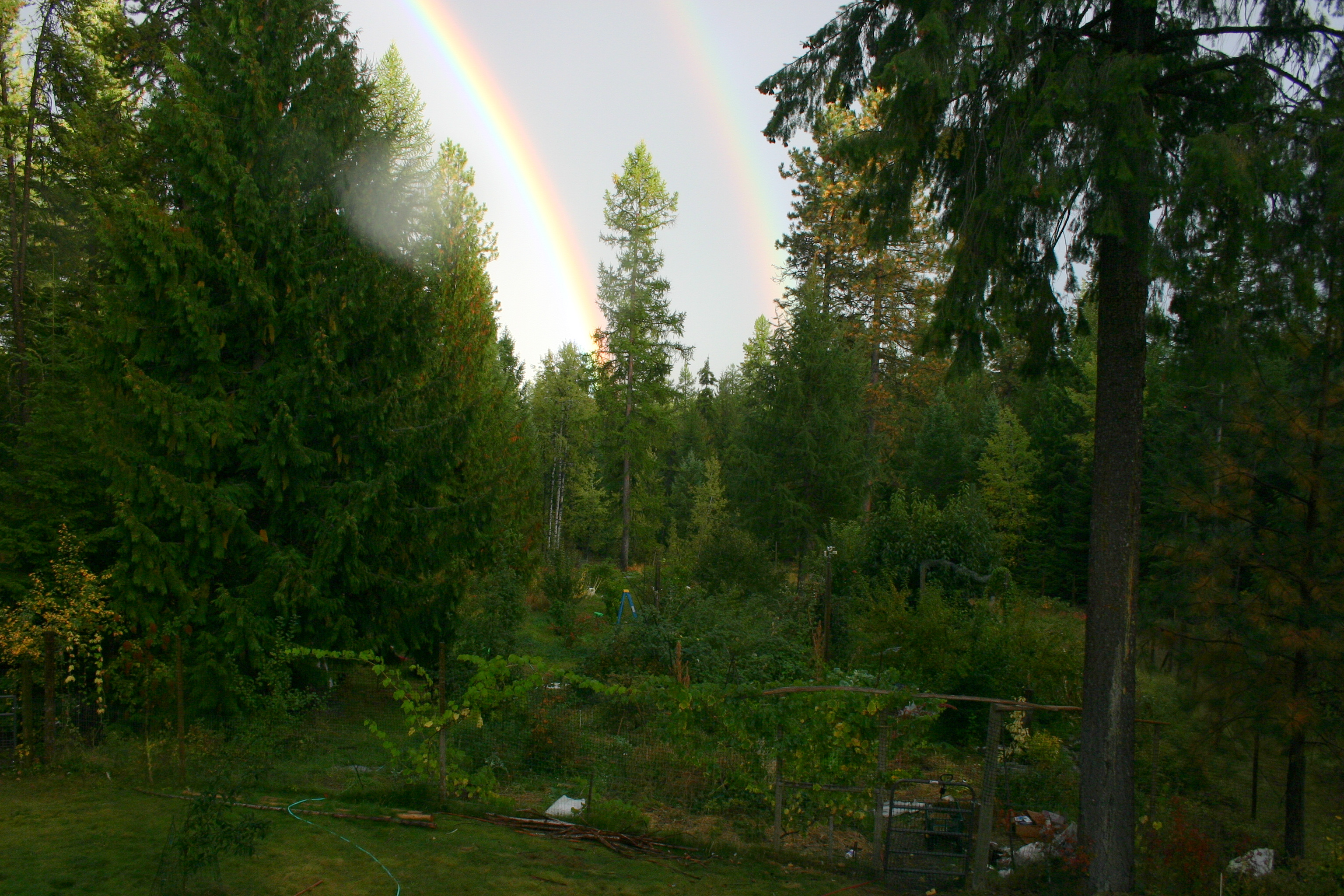
What does that mean in an out-of-balance system? Extremes, unpredictable unseasonal events and perturbations: simply put, things get weird in a big way. It’s 50” of rain in one event, wildfire seasons expanded by 105 days, and record-breaking wet springs followed by a record-breaking droughts. And from personal experience, a frost-free September at 5500’ in Montana with the 30th hitting a balmy 70◦ with plants still in full leaf. The next morning, the thermometer stood at 0◦. Needless to say, it appeared to be a botanical bloodbath. Fortunately we had designed for resilience, so most of our 300+ plantings rallied the next spring.
In addition to recognizing the potential natural risk events in your region, you need to know your local evolving weather patterns. An interactive NOAA website called Climate at a Glance[5] allows you to create historic graphs and predictive temperature, precipitation and seasonal graphs of your county from now to the end of the century. This information can help you make choices about where and what to plant or phase out as habitats, growing zones and rainfall change.
Plant hardiness zones[6] have shifted dramatically pole-ward and upward. Here in northeastern WA, we’ve gone from 4b to 6a in 40 years. That’s half the life-span of an apple tree…
Habitats for native trees and plants are changing with jaw-dropping speed. Phytomigration, the movement of plant species through different geographies over time in response to less than optimum growing conditions, has been occurring since plants existed. But usually, plants have had millennia to make their way to friendlier landscapes. Now habitats are changing in decades, far faster than plants can move. Multiple models will literally scare you out of your chair. A researcher from the US Forest Service’s Rocky Mountain Research Station has generated habitat change models[7] of 76 iconic native western tree and shrub species. Where I live, several of our ubiquitous native species have less than a 50% chance of finding suitable habitat here in 60 years. Think about that.
CAUSE AND EFFECTS OF DROUGHT, FLOODS AND WILDFIRES
To develop solutions to a problem, you need to know the foundational events or causes that created it and the conditions in which it thrives. Natural risks, like floods, droughts and wildfire, occur under complex sets of circumstances, unique in their effects and impacts based on specific regions and context. But they share common themes.
Floods are an excess of water on land that is normally dry. The water can neither sink into soil nor drain through established channels. The excess water comes from extreme atmospheric moisture, delivered at a speed and volume that overwhelms normal coping mechanisms. Wind, deforestation, lack of ground cover and hardened surfaces exacerbate the problem. Flooding displaces air in soils with water, causing plants to begin to suffocate or, in moving water, be ripped out of the ground.
Drought comes from the opposite situation, a profound lack of water vapor in the form of precipitation, snowpack and/or humidity.[8] Feeder roots and root hairs, many which reside in upper soil levels, dry out and die. Transport of nutrients and water slows. In prolonged drought, woody plant cells that transport water and nutrients (xylem and phloem) can permanently collapse. Repeated drought can kill even mature trees. With the substitution of extreme drying for excessive moisture, circumstances that lead to flooding likewise augment drought: wind, deforestation, lack of ground cover and hardened soils.
Wildfires needs an ignition source and three conditions to spread: heat (high temperature with low relative humidity), oxygen (wind), and fuels. Fuels have many characteristics: type, moisture content, shape, size, quantity, vertical arrangement and horizontal continuity. Wildfire behavior depends on three factors as well: topography, weather conditions and again, fuels, particularly the amount and arrangement. In fire-prone conditions, we find overly dense, dry vegetation blanketing the landscape, often with significant ladder fuels (vegetation under a tree canopy) that can carry ground fire into a forest canopy.[9]
Climate change, as discussed above, leads to dramatic weather events and perturbations along with alterations in temperature and moisture patterns, thus changing habitats. Common effects are random extremes in precipitation and temperature, increased wind, and deforestation. These are the same factors that make flooding, drought and wildfire more problematic.
Plants that are stressed can’t effectively combat disease or insect infestations, which can become epidemic in warmer temperatures. For example, mountain pine beetle have killed over 46 million acres of trees in the western U.S from 2000-2012, which leads to deforestation and increased risks[10], in a vicious feedback loop.
Simply summarized, wildfire, floods and drought share causes. Climate change exacerbates those causes while adding some significant ones of its own, most notably for agrarians, shifting wildlife/plant habitats and hardiness zones.
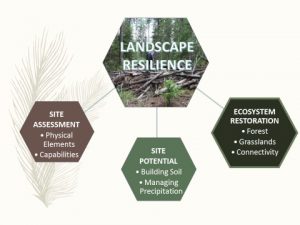
Identifying the leverage points where we can affect positive change through design and management are key to building resilience to natural risk. And those leverage points are at the nexus of our work as permaculturists: soil and habitat restoration, water and vegetation management and increasing biodiversity. To build resilience we must:
- Build soil so it stores water and carbon and promotes healthy, resilient growth of lifeforms.
- Maintain the right diversity, species composition and density to withstand high-risk natural phenomenon and a changing climate.
- Tie those actions together with appropriate water conservation and management.
- Employ biomimetic operation management techniques to increase resilience. Always ask how nature would solve the challenge you’re facing.
Managing natural risks pivots around the concept of modifying your land to create a network of water pathways and sponges, using soil and vegetation to collect and hold as much moisture as possible. It is possible regardless of your landscape or precipitation!
SITE ASSESSMENT
True to permaculture design, the first step in building resilience is an accurate site assessment to identify characteristics and capabilities. Identifying your site’s characteristics defines your design parameters and constraints – the boundaries of your sandbox. Honing in on the assets and liabilities that you can manipulate to maximize site capability, defines the tools and techniques providing the most effective action – how you can shape the sand.
Although all features play a role in determining your site’s existing and future potential, based on the accelerators of risk, these six are the most important elements affecting resilience:
- Aspect/Topography: direction faced and degree of slope strongly influence solar/heat gain potential, soil moisture retention, water run-off and fire behavior patterns as well as management options available.
- Wind: remember that wind is a major factor in exacerbating drought, wildfire and moisture retention in plants and soil.
- Soil: with a goal to create a living sponge of carbon-rich soil, the type of soils on your site dictates your primary actions.
- Precipitation: typical amount, seasonality and event types guide how you go about directing, capturing, storing and distributing water.
- Vegetation: actual and potential habitat, regional patterns, species, distribution, and density (above and below ground, horizontal and vertical arrangement). Plants, whether planted by nature or humans, are primary tools in your resilience work.
- Adjacent Risks and Assets: actions by others outside your property can affect your potential risk. Learning where natural threats may come from off-site and who is doing what ‘upstream’ allows you to leverage your actions for positive impact.
Pay particular attention to assets and liabilities that you can control, change or manipulate. Liabilities are often found in vegetation (too much, too little) and soils (low carbon content, low moisture retention, hardened surface). Water (quantity, movement through site, storage and distribution potential) and other resources (energy, biomass, equipment, skills…) typically are your key assets.
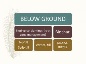
SOIL AND WATER MANAGEMENT
Building soil and managing water are your primary tasks in augmenting resilience. Soils rich in carbon and organic matter hold water. Permaculture and carbon farming along with smart management techniques give us a set of soil building tools below and above ground. Soil moisture can be augmented by no-till, strip till practices or keylines (vertical till). Adding biochar to soils attracts and holds nutrients, increases moisture retention by up to 30%, provides microbial and mycelial habitat, reduces greenhouse gas off-gassing and sequesters carbon.
Biodiverse plantings affect both below and above ground conditions. Appropriate root zone management allows maximum nutrient uptake and retention of soil moisture, while vegetation above ground shades soil and lowers surface temperature.
Above ground is also where we get to play with vegetation be it guilds, gardens, cover crops and grasses, or agroforestry techniques such as food forests, windbreaks, shelterbelts, riparian buffers and silvopastures. Of course, plant selection depends on growing zones (current and projected) and water needs. Increase your resilience by selecting varieties that bracket your current zone and then check those climate models and plant for the future conditions, even if that means adding some extra protection for a few years. And mulch, mulch, mulch.
Water management depends on our ability to locate and protect all sources, estimate volumes, keep it on site[11], capture it, store it, sink it, distribute it and love it. Sources can be natural (river, stream, pond, lake, spring, wetlands[12]), human-constructed (pond, catchment, container), subsurface (aquifer, underground flow), precipitation (rain, snow, dew), greywater or overflow (leakage from offsite).
The permaculture prescription of PATO – patient and thoughtful observation – suggests you go outside in every kind of precipitation event to see how your land responds. Recognize patterns. Where does the precipitation flow or get hung up? How do your buildings and infrastructure help or hinder? How much precipitation is effectively available?
Experts, like Brad Lancaster, have provided some great guidance[13] for water harvest principles and estimating volumes. Estimating available volumes can seem difficult but Lancaster and others provide the formulae for calculating specific run-off volumes from any surface from roofs to driveways to swales.
If you want to actually capture water in catchments or channels, first know your purpose(s). Is it flood or erosion control, irrigation, stock use and/or fire protection? Your purpose and site will then dictate how you deliver or guide that water to storage in containers, ponds or wetlands. Or conversely, how will you guide that water to key areas for storage in the soil by grading, berms, swales or terraces? You can also place things in the path of the water to diffuse or guide it. Vegetation, rocks, logs, straw bales, erosion socks or gabions can direct water. Or you can use subsurface channeling like French drains, perforated piping and keylines to move water.
Design your entire water network beginning at the top of your site first, then begin to implement slow, small solutions. A tweak upstream can have significant effects downstream. Use techniques that fit your site, capabilities and purposes while stacking functions.
How you manage and sequence your site operations can influence soil moisture retention as well. Planned grazing, forest thinning, livestock integration, mulch, tillage, irrigation and crop rotation can enhance or, if done without considering consequences, deplete soil moisture.
REJUVENATING FOREST LANDSCAPES
Native forests are in deep trouble across this country on public and private lands. One would like to think that public forest management practices have been predicated on science with sustainability of forest health being the primary driver. Based on decades of my work with and within land management agencies, it is abundantly clear natural resource decisions are social decisions. Science informs but ultimately, governments make decisions that prioritize short-term benefits to society over long-term impacts to people and nature. Climate change is a prime example.
But a second troubling example, coupled with climate change, has put our forests in real peril. Over 100 years of fire suppression has disrupted the natural balance within forests. Periodic fires historically have reduced biomass, created charcoal – a vital element for soil building- and created space for regeneration, all the while keeping site carrying capacity at optimal levels. Native cultures copied nature, using fire regularly to reinvigorate forest undergrowth and prairies, regenerating culturally important plants and providing high quality forage for wildlife. Old-growth of most tree species easily withstood rapidly moving ground fires and were healthier for them.
Fire suppression was demanded of politicians early last century as people settled in forested regions. Politicians were happy to oblige despite warnings of scientists that comprehensive suppression would actually increase fire severity and disrupt forest dynamics over time. It’s now clear that wildfire suppression has allowed forests to significantly increase the density of individual trees per acre. These trees compete for water and nutrients. Few actually thrive.
Increased density augments the number of shade-tolerant species which need to grow up under shade-intolerant species, then outcompete them. Shade-intolerant species, like ponderosa pine, are much more resistant to fire. But now, shade-intolerant trees dominate most forests and they are notoriously sensitive to fire. When a wildfire does start, the chances of it becoming an inferno are now much higher. The heat generated by a dense understory is sufficient to send flames into the canopy and many trees that could otherwise withstand a ground fire are killed.
Thinning to reduce tree density, removing thick undergrowth (goats and some sheep breeds are highly skilled at this!) and removing limbs to 10’ up are key practices. The USDA Natural Resources Conservation Service (NRCS) and state forestry departments often have free expertise and grants to help you pay for 50-100% of the treatments. They, as well as the US Forest Service, conservation districts, university extension offices (found in just about every county), and the National Fire Protection Association, offer education and information across the country. Just visit any of their offices or search the internet for the Firewise USA Toolkit[14] to get started.
Importantly, you’ll find that appropriate thinning always improves the aesthetics of your property and the vigor of herbaceous ground covers. Sure, it will take some maintenance to maintain it in a more open pattern but the property value and functionality, as well as the health of your forest ecosystem, will be vastly improved.
Prescribed burning is highly effective as a post-thinning tool. Because of the inherent risks of escape and residual damage, leave this to professionals.
Once some Firewise thinning starts in a neighborhood, more and more property owners follow suit. Hundreds of acres around us are now Firewise, so everyone wins!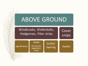
SOLUTIONS SUMMARIZED
Once you understand primary natural risks and their causes, the solutions seem quite logical. There is a plethora of information available on each of these activities. Taking action not only makes your property more resilient but you are also helping your community by your positive example. Not every one of these will suit your property or purposes but each is worthy of consideration.
- Educate yourself on projected climatic changes for your region and county.
- Build your soil through compost, biochar, mulch, cover crops, manure, worms…
- Plant some species at the margin of your hardiness zone, protect over winter.
- Select varieties with a wide range of hardiness suitability, especially to the warm side.
- Begin container-raising cold sensitive plants in a greenhouse or hoop house for planting out 5 years from now.
- Propagate your own varieties which seem to stand up well to extremes, especially heat.
- Plant a range of varieties of a particular species with different bloom and ripening periods.
- Increase biodiversity and plant arrangement, vertically and horizontally.
- Thin your forests according to Firewise guidelines.
- Reduce height and density of understory in non-irrigated forests.
- Limb up trees to 10’ above ground.
- Convert waste woody biomass to biochar, compost softer organic materials.
- Plant shade-intolerant and thick-barked trees that have higher fire resistance.
- Create windbreaks, a handy agro-friendly tool critical for de-escalating natural risk.
- Create fuel breaks, open patches or ‘lanes’ through forests, to slow wildfire spread and speed.
Enjoy the journey!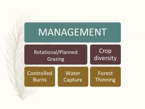
[Published in Permaculture Design Magazine, Winter/February Issue #107, https://www.permaculturedesignmagazine.com]
Gloria Flora is the founder and director of Sustainable Obtainable Solutions, a non-profit dedicated to the sustainability of public lands; founder of the US. Biochar Initiative; board member of The Permaculture Land Trust; former national forest supervisor; landscape architect and certified permaculture designer. She and her husband are growing TerraFlora Permaculture, a learning center in NE WA, where they demonstrate agroforestry and polyculture solutions within 65 acres of native forest. And yes, Flora is their real last name.
[1] Conservation Generation: How Young Farmers and Ranchers Are Essential to Tackling Water Scarcity in the Arid West youngfarmers.org/westernwater
[2] National Atmospheric Science Administration, 2016 http://climate.nasa.gov/evidence/
[3] CO2e: A unit of measurement of the global warming potential of greenhouse gases using the functionally equivalent (e) amount or concentration of carbon dioxide (CO2).
[4] October 2017. Mauna Loa Observatory, Earth Systems Research Laboratory, National Oceanic and Atmospheric Administration, U.S. Department of Commerce. https://www.esrl.noaa.gov/gmd/ccgg/trends/
[5] Many US government agencies are being forced to eliminate references to and information about climate change by the current administration. At last check, Climate at a Glance was still reachable at https://www.ncdc.noaa.gov/cag/time-series/us/45/9/tavg/ytd/12/1895-2016
[6] Current USDA Agricultural Research Service Plant Hardiness Maps are found at http://planthardiness.ars.usda.gov/PHZMWeb/ . A map showing changes since 1976 can be found at http://www.washingtonpost.com/wp-srv/special/local/planthardinesszones/index.html?tid=a_inl
[7] http://forest.moscowfsl.wsu.edu/climate/species/index.php
[8] For a good overview of drought impacts on woody plants see: Douglas, Sharon. Drought, Its After Effect and Management Strategies for Woody Ornamentals. Connecticut Agricultural Experiment Station.
[9] Basic wildfire information can be found at https://ir.library.oregonstate.edu/downloads/qr46r108p
[10] Interestingly, on a broad landscape scale, insect-killed trees do not necessarily increase wildfire risk. Other factors are far more dominant, including the overall poor health of forests. See Meigs, Garret, et.al.. Does wildfire likelihood increase following insect outbreaks in conifer forests? Ecosphere. Volume 6, Issue 7. July 2015. Pages 1–24 http://dx.doi.org/10.1890/ES15-00037.1
[11] Know water-rights law for your state and region before you start designing.
[12] Integrate complementary uses around wetlands – don’t drain!
[13] Thank you Brad Lancaster, author Rainwater Harvesting for Drylands and Beyond.
[14] http://firewise.org/wildfire-preparedness/firewise-toolkit.aspx
0 Comments